Friday, August 4, 2006

Artboretum

Earlier this year, my father and I visited the arboretum at Palomar College. We traveled about 50 miles from south San Diego County to see it, after reading their web site and thinking we’d found a gem.

To put it bluntly, we were appalled. The arboretum appears to have been completely neglected for some years; dead and dying specimens are everywhere. Only the weeds were thriving. Labels and signs — a key part of any arboretum — were largely missing.

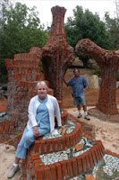
And in the middle of this aboretum disaster was the … thing … shown in the photo at right. It looked as beat up and defeated as the rest of the arboretum to us. A sign identified it as a work of art, and it’s a good thing there was a sign — otherwise we’d have been hard put to figure out just what it was. I know I’m displaying my primitive sense of art here, but … I can’t help but associate art with beauty. And beautiful this thing ain’t. It’s beyond me why anyone would want such a thing in the middle of what could be a beautiful arboretum.

But now I read that the “Friends of the Palomar College Arboretum” actually moved this piece of “art” into the arboretum they are in charge of. And they’re out there raising money through donations to have the original artist (a local, James Hubbel) design the surrounding display area and help with refurbishing the sculpture. They’re trying to raise $40,000 to $50,000 dollars to accomplish this. And they’re trying to bring more “art” into the arboretum.

I have a modest suggestion for the Friends of Palomar College Arboretum: figure out what your mission is, make your name reflect it, and then concentrate on that. If you really want to be the “Friends of Palomar College Home for Orphaned Outdoor 'Art'", then change your name and quit pretending to be an arboretum — put your dying specimens out of their misery and put in some gravel and silk plants. On the other hand, if you really want to be Friends of the Palomar College Arboretum", perhaps you should consider addressing the 50,000 or so things about the arboretum that should be a higher priority for you than salvaging pieces of art. Things like, say, keeping your specimen plants alive! You might even get a couple of hundred bucks together and label the four or five specimens that are still surviving!

Sheesh.

The North County Times has an article about this.

Title

Israel’s war with Hezbollah is acting as a kind of flashlight, illuminating the dark corners of politics all over the world.

A few things seem to be uncontroverted by any serious observer:

— Hezbollah’s goal is to eliminate Israel, preferably killing all the Jews in the process.

— Hezbollah deliberately targets civilians in Israel, and deliberately makes targets of civilians in Lebanon, all because of the high propaganda value of dead and maimed civilians of any nationality.

— Hezbollah is lavishly armed and trained, and occupies a large fraction of Lebanon, in defiance of UN proclamations and the Lebanese government.

— Hezbollah is actively supported by the governments of Syria and Iran, receiving hundreds of millions of dollars in financial support, plus millions of rounds of ammunition, hundreds of thousands of artillery shells, and tens of thousands of various kinds of missiles.

— Hezbollah has been fighting a guerilla war against Israel for over 10 years, sending suicide bombers, missiles, and artillery over the border from Lebanon to target Israeli civilians. Hundreds of Israelis have been killed and maimed in these cruel and barbaric attacks.

— The stated goal of Iran’s government is to “wipe Israel from the map”.

Then a few weeks ago, Hezbollah made a very provocative escalating attack against Israel (invading Israel with a military force, killing several soldiers and capturing two alive), and accelerated their missile bombardment. Israel said “Enough!” and basically declared open war on Hezbollah, with the explicit objective of eliminating Hezbollah’s capability to wage war against Israel (especially its ability to fire missiles into Israel).

My own take on this is, apparently, a distinctly minority view in the world’s community. I think it’s absolutely marvelous that the Israelis are taking on Hezbollah, and I wish them well in their war. I hope they don’t stop until every Hezbollah fighter is dead or surrendered. I hope they eliminate Hezbollah as a credible player on the Middle Eastern stage. I hope that all this chatter about “ceasefires” (as if you could have a ceasefire with terrorists!) and “disproportionate response” (as if that was a bad thing!) is ignored by Israel and the U.S., and doesn’t impede their efforts in the slightest. In the end, I’d like to see a democratic, secular Lebanese government that can be a stabilizing force in the heart of the Middle East — a partner to the U.S., Israel, Turkey, and Iraq, and a shining example to the masses living under autocrats in places like Iran, Egypt, Syria, and Saudi Arabia.

None of this will ever happen while Hezbollah occupies Lebanon and wages war on Israel.

But the most of the world (including the American left) doesn’t agree with me. There are varying positions, but the general consensus is that we must have an immediate ceasefire. I think it’s fair to say that most people in the world believe that Israel’s response is somehow unfair, or has ulterior motivations. The majority would like to see pressure put on the Israelis to stop fighting Hezbollah, and to withdraw from Lebanon.

In an article at the National Review, Victor Davis Hanson writes:

Our present generation too is on the brink of moral insanity. That has never been more evident than in the last three weeks, as the West has proven utterly unable to distinguish between an attacked democracy that seeks to strike back at terrorist combatants, and terrorist aggressors who seek to kill civilians.

I think Mr. Hanson is exactly right, and this war is acting like a flashlight to illuminate those morally insane people he’s talking about. Like Rep. John Dingell (D, Michigan) who said “I don’t take sides for or against Hezbollah.” Or John Kerry (D, Massachussets), maneuvering for political points, declaring that the Israel-Hezbollah war “would never have happened” had he been elected. Or any of dozens of other morally bankrupt statements and essays we’ve been treated to over the past few weeks, from both domestic and foreign wackos.

What to do? The best lesson I can take away from this flashlight’s revelations is to remember — remember which people said what, and (especially with respect to the U.S. politicians) take that into account the next time there’s an election. If enough morally sane people can do that, maybe we’ll have enough to make a difference.

I sure hope so, 'cause what I’m hearing now is downright dispiriting…

Wednesday, August 2, 2006

Lamestream Parody

Tip o’the hat to JimM for this gem:

The Pope is visiting Washington, D.C., and President Bush takes him out for an afternoon on the Potomac, cruising on the Presidential yacht, the Sequoia. They’re admiring the sights when, all of a sudden, the Pope’s hat (zucchetto) blows off his head and out into the water.

Secret Service guys start to launch a boat, but President Bush waves them off, saying, “Wait, wait. I’ll take care of this. Don’t worry."

Bush then steps off the yacht onto the surface of the water and walks out to the Holy Father’s little hat, bends over, picks it up, and then walks back to the yacht and climbs aboard. He hands the hat to the Pope amid stunned silence.

The next morning, the headlines in the New York Times, Boston Globe, Atlanta Constitution, Washington Post, Boston Herald, Buffalo News, Houston Chronicle, Milwaukee Sentinel-Journal, Minneapolis Tribune, Denver Post, Albuquerque Journal, Los Angeles Times, and San Francisco Chronicle all proclaim:

"Bush Can’t Swim!"

Oh, come on now — you know that’s exactly what would happen!

Rain in July...

And pretty soon, you’ve got a half inch of rain. In these parts, a half inch of rain is not the usual July experience — July here is normally comprised of wall-to-wall blue skies, hot and dry days, and cool, comfortable nights. This July saw us with relatively humid days (along with the hot), quite a few uncomfortably warm nights, and rain.

Weirdness!

But welcome weirdness. The native desert plants that surround us are experts at slurping up this unexpected moisture; they will all benefit (and they were already in robust good shape because of the spring rains). The weeds will most likely pop up again — we’ll know that in a day or two. And perhaps most importantly: the fuel (mainly dead plant material, wood, twigs, and leaves) is now all dampened down again, and it will take a bunch of hot, dry days to dry it all out. That translates into reduced fire danger for several weeks, at least.

We like rain!

Monday, July 31, 2006

Birds and Fire

For the past couple of days we’ve been marveling at the huge number of hummingbirds and orioles that suddenly appeared at our nectar feeders — double or more our usual number. We’ve seen as many as 50 hummingbirds simultaneously buzzing around just 4 feeders. We have two windows with 4 feeders, and both sets of feeders are equally busy.

This afternoon, Debbie made the connection between the appearance of the birds and the Horse Fire — and I suspect she’s totally correct. I’ll bet you we’re hosting a few hundred hummingbirds, and perhaps a dozen hooded orioles (hooded and Bullock’s).

They’re a real treat for us to see, and I suspect we’re actually helping them survive, as well.

With just a little sugar and food coloring…

Quote of the Day

Put down any hot beverages, swallow anything in your mouth, then read:

"If a drunken Mel Gibson did indeed call out, 'Jews are responsible for all the wars in the world,' then there can be only one possible place for a man who believes such things: as the next Secretary General of the United Nations."

David Frum, writing at National Review.com

Kofi deserved that one richly. Well delivered, Mr. Frum!

Yalla Ya Nasrallah

Nasrallah, of course, is the leader of Hezbollah in Lebanon (and currently rumored to be cowering in the basement of the Iranian embassy in Beirut). This song is Israeli, in Hebrew, with English subtitles.

Just go watch it!

Best. Music. Video. Ever!

Sunday, July 30, 2006

Hezbollah, the Bar Bully

Over at the FreeRepublic, there’s a post that makes the case for why the world should stand aside while Israel beats the living hell out of Hezbollah, until Hezbollah gives up. This is so good I’ve reproduced it in its entirety — and I hope this post will entice you to visit the excellent FreeRepublic often…

Posted by MBombardier at FreeRepublic:

I once witnessed a bar fight in downtown Olongapo (Philippines) that still haunts my dreams. The fight was between a big oafish Marine and a rather soft-spoken, medium sized Latino sailor from my ship.

All evening the Marine had been trying to pick a fight with one of us and had finally set his sights on this diminutive shipmate of mine…figuring him for a safe target. When my friend refused to be goaded into a fight the Marine sucker punched him from behind on the side of the head so hard that blood instantly started to pour from this poor man’s mutilated ear.

Everyone present was horrified and was prepared to absolutely murder this Marine, but my shipmate quickly turned on him and began to single-handedly back him towards a corner with a series of stinging jabs and upper cuts that gave more than a hint to a youth spent boxing in a small gym in the Bronx.

Each punch opened a cut on the Marine’s startled face and by the time he had been backed completely into the corner he was blubbering for someone to stop the fight. He invoked his split lips and chipped teeth as reasons to stop the fight. He begged us to stop the fight because he could barely see through the river of blood that was pouring out of his split and swollen brows.

Nobody moved. Not one person.

The only sound in the bar was the sickening staccato sound of this sailor’s lightning fast fists making contact with new areas of the Marine’s head. The only sound I have heard since that was remotely similar was from the first Rocky film when Sylvester Stallone was punching sides of beef in the meat locker.

Finally the Marine’s pleading turned to screams…a high, almost womanly shriek. And still the punches continued relentlessly. Several people in the bar took a few tentative steps as though they wanted to try to break it up at that point, but hands reached out from the crowd and held them tight. I’m not ashamed to say that mine were two of the hands that held someone back.

You see, in between each blow the sailor had begun chanting a soft cadence: Say [punch] you [punch] give [punch] up [punch]…say [punch] you [punch]were [punch] wrong [punch]”.

He had been repeating it to the Marine almost from the start but we only became aware of it when the typical barroom cheers had died down and we began to be sickened by the sight and sound of the carnage. This Marine stood there shrieking in the corner of the bar trying futilely to block the carefully timed punches that were cutting his head to tatters…right down to the skull in places. But he refused to say that he gave up…or that he was wrong.

Even in the delirium of his beating he believed in his heart that someone would stop the fight before he had to admit defeat. I’m sure this strategy had served him well in the past and had allowed him to continue on his career as a barroom bully.

Finally, in a wail of agony the Marine shrieked “I give up", and we gently backed the sailor away from him.

I’m sure you can guess why I have shared this story today. I’m not particularly proud to have been witness to such a bloody spectacle, and the sound of that Marine’s woman-like shrieks will haunt me to my grave. But I learned something that evening that Israel had better learn for itself if it is to finally be rid of at least one of its tormentors:

This is one time an Arab aggressor must be allowed to be beaten so badly that every civilized nation will stand in horror, wanting desperately to step in and stop the carnage…but knowing that the fight will only truly be over when one side gives up and finally admits defeat. Just as every person who had ever rescued that bully from admitting defeat helped create the cowardly brute I saw that evening in the bar, every well-intentioned power that has ever stepped in and negotiated a ceasefire for an Arab aggressor has helped create the monsters we see around us today.

President Lahoud of Lebanon, a big Hezbollah supporter and a close ally of Syria, has been shrieking non-stop to the UN Security Council for the past two days to get them to force Israel into a cease fire.

Clearly he has been reading his autographed copy of 'Military Success for Dummies Arab Despots' by the late Gamal Abdel Nasser of Egypt. Ever since Nasser accidentally discovered the trick in '56, every subsequent Arab leader has stuck to his tried and true formula for military success:

1. Instigate a war.

2. Once the war is well underway and you are in the process of having your ass handed to you…get a few world powers to force your western opponent into a cease fire.

3. Whatever you do, don’t surrender or submit to any terms dictated by your enemy. That would ruin everything! All you have to do is wait it out and eventually the world will become sickened at what is being done to your soldiers and civilian population…and will force a truce.

4. Once a truce has been called you can resume your intransigence (which probably caused the conflict in the first place), and even declare victory as your opponent leaves the field of battle. This tactic has never failed. Not once. In fact it worked so well for the Egyptians in 1973, that to this day they celebrate the Yom Kippur War - a crushing defeat at the hands of Israel - as a military victory! No kidding…it’s a national holiday over there!

President Lahoud has already begun to shriek like a school girl to the UN Security Council to “Stop the violence and arrange a cease-fire, and then after that we’ll be ready to discuss all matters."

Uh huh. Forgive me if I find that a tad hard to swallow. He allowed Hezbollah to take over his country. He allowed the regular Lebanese army to provide radar targeting data for the Hezbollah missile that struck the Israeli destroyer. He has turned a blind eye while Iranian and Syrian weapons, advisers and money have poured into his country. And now that his country is in ruins he wants to call it a draw. As much as it may sicken the world to stand by and watch it happen, strong hands need to hold back the weak-hearted and let the fight continue until one side finally admits unambiguous defeat.

Well said. I’m a long way from an expert on the Middle East, but what MBombardier proposes makes eminently good sense to me. I’m good and ready for a significant terrorist group to be so badly damaged that they’re forced into the humiliating position of having to give up, and having to admit they were wrong. Even better to have the object of their torment — Israel — be the one doing the damage. I still have some hope that this scenario is actually exactly what’s happening behind the scenes…

Tip of the hat to MikeD for the pointer…

Saturday, July 29, 2006

Horse Fire XVI

The map at right shows the satellite data (both WF-HMS and MODIS) overlayed with the Horse Fire’s perimeter (determined after the fact by human survey teams). It’s very interesting to see how they differ…

The east and west flanks of the fire both have particularly misleading satellite information — they show the fire extending well beyond where it actually was. On the western flank (the one nearest us), there are a couple of satellite paints and WF-HMS data (analyzed by a human) that show the fire extending toward us more than a mile further than it actually did.

On the northeast section of the fire, on the other hand, there are large areas that did burn for which there is no satellite data at all.

The biggest lesson I’ve learned from this experience is that the satellite data simply can’t be relied on. No matter how carefully I qualified the data (e.g., by how far away the satellite passed over), and even relying on the expertise of the NOAA analysts, the satellite data simply didn’t give us accurate information. And depending on the vagaries of the satellite’s orbits, it wasn’t always timely, either. I think the information we got by watching the smoke plumes from our yard was about as accurate and timely as the satellite data — and maybe even more so. The satellite data is just an indicator, and needs to be thought of in that way.

All the more reason to be happy that I’ve got the scanner…

Scanner

The recent Horse Fire was close enough to our home to make us very worried that it might burn us. During the fire, our biggest frustration was not getting accurate information in a timely manner. Several times we found ourselves in a situation where we had enough information to be concerned about an immediate threat, but not enough to know if we should start packing the vehicles for evacuation. This was very frustrating, and a couple of times we ended up taking a chance by doing a reconnoiter so we could either see for ourselves what was happening, or get some accurate information from someone who had seen for themselves. The risk there is that the fire could break out while we were away from home — we would never have done this if it had been windy, but fortunately it was not windy during the Horse Fire.

But this got me to pondering how I could possibly be better prepared the next time we have a fire in the area. It occurred to me that if I could listen to the radio communications of the fire and police, I’d most likely be able to learn a lot, as it happened, and from the horse’s mouth, so to speak. And that made me think of scanners, those radio receivers that “scan” a whole bunch of different frequencies, stopping when they hear someone talking on one. At least, that’s the way scanners worked the last time I had any contact with one, which was something like 20 or 25 years ago.

So I did some research on the web, and first I discovered that much (though not all) of the police and fire communications these days are handled on what are called “trunked” radio systems. These trunked systems work in a very different way than the radios of yesteryear. In particular, it’s no longer true that one particular radio “talks” on one particular frequency on these systems. Instead, each system is capable of talking on many frequencies, and the central system assigns a frequency each time the talk button is pushed. The central system keeps track of who’s talking on what frequency, and broadcasts that information on a special “control channel” frequency, with digital or analog codes. An old-fashioned scanner of the type I knew about would not be usable with these trunked systems, so at first I thought my idea was in trouble.

But with a little more research, I discovered that the scanner manufacturers have kept up with this technology, and scanners for trunked systems are readily available. After some research I settled on one particular model: the Uniden BCD996T. I got the unit a couple of days ago, and over the past couple of evenings and this morning I learned how to set it up for our local fire and police communications. The easiest way to configure this thing, by far, is to use the PC software that comes with it. It’s possible to do it all through the front panel, but very tedious; much less tedious with the software. This morning I entered the last of almost 400 frequencies and channels. Now the unit is sitting on my desktop, scanning away like mad.

Even though I’m a geek, I find myself completely amazed at the capabilities of this scanner. It has some very smart behaviors built in that make the scanning much more effective. For example, once it discovers someone talking on a particular channel and code, it will check that channel and code more frequently, making it more likely that you’ll catch the entire conversation — this works very well. The audio quality isn’t what I expected at all — it’s not the static-filled AM that I remember from 20 years ago; the modern systems are almost all FM and nearly static-free. And the sensitivity to weak signals is just awesome, especially by comparison to the radios of the 1960s, when I last did any serious RF work.

I’m particularly pleased with the ability to hear the firemen in the field, still working on the Horse Fire. I can hear the guys with walkie-talkies, way out in the boonies, as they work away at hot spots. This morning it is drizzling here, and I heard one team decide not to go into a steep-sided gorge, because they were afraid they couldn’t get out if the roads were wet. In the course of this conversation, they rattled off their GPS coordinates, so I was able to locate them precisely on a map. This is exactly what I hope to be able to do during a fire next time…

Next weekend I’ll be putting up a better antenna for my scanner. Right now I’m operating on just the little whip that came with it. A high-gain antenna, located outside and away from the electronic noise in the house, should work much better yet — especially for the weaker signals from walkie-talkies down in canyons, etc.

Debbie and I, as we listened this morning to the firefighters on the radio, were kicking ourselves for not having done this long ago. I’d encourage anybody living in the chaparral to get one of these scanners. And if you happen to live in San Diego, and you decide to get the same model that I did, I’d be more than happy to share the programming files with you (what Uniden calls “System” files) — just email me, and I’ll send them along…

Friday, July 28, 2006

One Liner of the Day

James Taranto notes this news story:

“Tour de France winner Floyd Landis denied on Thursday taking performance-enhancing drugs during the race and said he would fight to clear his name after testing positive for the male sex hormone testosterone,” Reuters reports.

And makes this quip:

Only the French would consider the presence of testosterone in a man’s system suspicious.

Ooooh…how I wish I’d thought of that!

1955

Hat tip to reader Richard F. for these gems…actual comments that ordinary people made in 1955.

I know a few younger folks that would have trouble believing these!

"I’ll tell you one thing, if things keep going the way they are, it’s going to be impossible to buy a week’s groceries for $20."

"Have you seen the new cars coming out next year? It won’t be long before $2000 will only buy a used one."

"If cigarettes keep going up in price, I’m going to quit. A quarter a pack is ridiculous."

"Did you hear the post office is thinking about charging a dime just to mail a letter?"

"If they raise the minimum wage to $1, nobody will be able to hire outside help at the store."

"When I first started driving, who would have thought gas would someday cost 29 cents a gallon. Guess we’d be better off leaving the car in the garage."

"Kids today are impossible. Those duck tail hair cuts make it impossible to stay groomed. Next thing you know, boys will be wearing their hair as long as the girls."

"I’m afraid to send my kids to the movies any more. Ever since they let Clark Gable get by with saying 'damn' in 'Gone With The Wind,' it seem’s every new movie has either “hell” or “damn” in it.

"I read the other day where some scientist thinks it’s possible to put a man on the moon by the end of the century. They even have some fellows they call astronauts preparing for it down in Texas ."

"Did you see where some baseball player just signed a contract for $75,000 a year just to play ball? It wouldn’t surprise me if someday they’ll be making more than the president."

"I never thought I’d see the day all our kitchen appliances would be electric. They are even making electric typewriters now."

"It’s too bad things are so tough nowadays. I see where a few married women are having to work to make ends meet."

"It won’t be long before young couples are going to have to hire someone to watch their kids so they can both work."

"Marriage doesn’t mean a thing any more; those Hollywood stars seem to be getting divorced at the drop of a hat."

"I’m just afraid the Volkswagen car is going to open the door to a whole lot of foreign business."

"Thank goodness I won’t live to see the day when the Government takes half our income in taxes. I sometimes wonder if we are electing the best people to congress."

"The drive-in restaurant is convenient in nice weather, but I seriously doubt they will ever catch on."

"There is no sense going to Lincoln or Omaha anymore for a weekend. It costs nearly $15 a night to stay in a hotel."

"No one can afford to be sick any more; $35 a day in the hospital is too rich for my blood."

"If they think I’ll pay 50 cents for a hair cut, forget it."

My favorite: “…I sometimes wonder if we are electing the best people to congress."

Hah!

Horse Fire XV

Last night at 6 PM the roadblocks on Lyons Valley Road came down. We were the first ones through the roadblock on the south side, waving to the CHP officer who had been manning it, and now looked very relieved to be done with this duty.

The photo above right is a panorama I made by stitching together seven individual photos. I took this while standing on the eastern edge of the “helispot” that’s along Lyons Valley Road, a mile or so south of the intersection with Japatul Road. Interestingly I saw no evidence that the helispot had been used — even though it was built (at considerable cost) for the express purpose of providing a place to load, unload, and refuel helicopters in an emergency. I could see several other places that did appear to be used for air support, including the large parking lot just south of the helispot. Go figure.

Anyway, you can see (if you click on that panorama) the Secret Canyon area, to the northeast of the helispot, under the clouds. This is in the Pine Creek Wilderness, some very rugged and inaccessible territory.

The leftmost photo below shows the Barrett Honor Camp — it’s an oasis of green amidst the burned area. I’m sure there’s a story there about how they saved that camp…

The next photo is taken from the helispot, looking up Horsethief Canyon. Just out of sight, over the next ridge, is an area full of homes — the firefighters stopped the fire before it got there.

The last two photos show some of the “mop up” operations going on last night (and continuing today). The truck is wetting down a dirt road; the helicopter is looking for hot spots that might flare up again.

We drove all the way to the north end of Lyons Valley Road, where it tees onto Japatul Road. Despite the satellite data and verbal reports to the contrary, our eyeballs tell us that the fire never crossed to the west side of Lyons Valley Road — so the eastern flanks of Gaskill and Lawson Peaks are still green. There’s a lesson in there about how to read the satellite data, though I’m not entirely sure yet what that lesson is…

The piece of good news in all this, at least for Lawson Valley residents, is that a roughly 45 degree swath of our risk aperture (for Santa Ana driven wildfires) has had the fuel removed. It’s the same effect that would occur from a controlled burn, though I can’t imagine any government agency approving a controlled burn of this magnitude. This is a significant reduction in our risk of wildfire…

Thursday, July 27, 2006

Horse Fire XIV

We got back from our reconnoiter yesterday afternoon and discovered that our satellite Internet connection had gone down. We’re working with our ISP to get full connectivity back; meanwhile we’ve got just a laptop connected and we can (sort of) post on the blog and monitor email.

The reconnoiter: the roadblock was still up, but the two CHP fellows manning it told us that they were hearing (this is 2:30 PM yesterday) that the fire was nearly out — and our eyeballs told us the same thing, as we saw only a couple of very small smoke plumes. The CDF site this morning is reporting 25% containment — and the satellite is showing only a couple of red dots on the WF-HMS data, and nothing whatsoever on the MODIS data.

We’re reading this as the fire is all but out, though there is a (hopefully very small) risk of a flareup until they get a perimeter around the whole thing.

Very, very good news for all of us in the area surrounding the fire!

Wednesday, July 26, 2006

Horse Fire XIII

The map at right has the latest MODIS paints — none! Some of the older paints have completely fallen off ('cause they’re older than 48 hours). But on the last pass — almost directly overhead, too — the MODIS imaging didn’t find a single pixel of thermal signature for fire. The most likely reason for this is that there were no large fires left burning, just isolated smaller fires (these don’t produce enough heat to cross the MODIS threshold).

I called CDF, and their recording is now sounding positively chipper. In particular, it mentions no threat of any kind from the western flank of the fire (the one closest to us). Yahoo! They do talk about some remaining risk at Secret Canyon and Lake Morena (the orange shaded areas), but mostly they talked about containment, the need for 20 miles of perimeter construction, and the vast array of men and equipment on the scene.

We’re going to take off on a reconnoiter; if we learn anything new we’ll post within a few hours.

Horse Fire XII

Just got off the phone with a real, live — and informed — CDF person. He reports that the brunt of the fight on the Horse Fire is now on its western flank (closest to us), and that so far the firefighters there have managed to keep it all east of Lyons Valley Road, and south of Japatul Road. That’s great news for us!

Not so great news for us: the weather service is forecasting that the winds today will be toward the southwest, but light (definitely NOT a Santa Ana condition!). This would have the fire tending in our direction, with the uphill slopes it would first run into heading straight toward us.

We’re hoping those firefighters continue to prevail, and keep that horse’s ass of a fire over on the other side of the road!

The most recent MODIS data is now 12 hours old, so almost irrelevant. The next pass of a MODIS satellite is Terra, which will fly over in about 90 minutes, about 800 miles to the east. It’s just over 400 miles high, so that will give it a very oblique view (about 25 degrees). Assuming its sensors see that wide a path (I’m not sure about this), then it should have a great view of the eastern flanks of Gaskill and Lawson Peaks…

Horse Fire XI

We just got an update to the WF-HMS data. This is the data that is generated by a human analyst at NOAA, who takes into consideration all the available data (including imagery).

The green splotch, as usual, is where our home is located. This is zoomed in to show only the southwestern flank of the Horse Fire. The data of interest here are the small red and yellow dots — the red dots indicate fires located by the analyst within the past 24 hours, yellow dots are between 24 and 48 hours old. There are several new red dots, including one right smack in the middle of the community of Carveacre (that’s the dot by itself in the grey area, on the northwest side of the visible fire area). There are also more red dots in the area just to the north and to the east of Lake Barrett.

If this data is accurate, our hearts go out to the folks who live in Carveacre…

The areas closest to our home, with the big one kilometer diameter red MODIS splotches, doesn’t have any red dots at all — we’ll take that as good news.

And we can’t help but be amused by the red dot located right in the middle of Lake Barrett. That’s a good reminder of the “coarseness” of these data — the small red dot implies a much higher precision than is actually present. It’s entirely possible that the red dot in Carveacre is actually misplaced, much like the one in Lake Barrett. We sure hope so…

Horse Fire X

We got a bit of new satellite data last night, and with this data alone you would now think that the major part of the fire is the part nearest our home. Yikes!

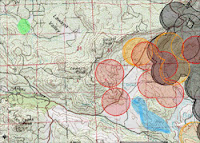
On the upper map, at right, the green splotch is where our home is, and the hand-drawn orange areas are where the verbal CDF reports say the fire is. For the southwest flank (the part nearest our home) and the southeast flank (the part nearest Lake Morena), the verbal reports jibe well with the satellite data. For the northern flank, all we have are the verbal CDF reports — in a dozen or so satellite passes, we’ve never seen a single pixel of data concerning heat or flares in Secret Canyon. This makes me wonder if the verbal CDF reports are just plain wrong, and the fire is actually south of Secret Canyon, where those black MODIS paints, and the two active WF-HMS red dots are…

CDF reported late last night (after we went to bed) that the fire was now 15% contained and had burned 16,384 acres. I’m not sure how they estimate containment. My guess would be the percentage of the perimeter that they have a secure firebreak around, but that’s just a guess. The burned acreage jumps right out at a geek like me: 16,384 is an even power of two (2^14, or 128^2) — a frequently encountered number in the world of a programmer who’s familiar with machine-level operations. It seems somehow unlikely that the estimated acreage accidentally came out as such a number. More likely is the estimation algorithm is being exposed here, somehow…

The lower map is really just for your interest. It’s the NOAA near-realtime map with every reporting option turned on (and a legend visible). The red dots are the results of human analysis; all the other dots are automated systems — algorithms running on sensor data.

Until yesterday, CDF was reporting that the cause of the Horse Fire was “under investigation”. Early lamestream media reports said it was an illegal immigrant’s campfire, but they soon backed off of that statement. Now the CDF is reporting the cause as an “escaped campfire”. So far as I know, the area where the fire started doesn’t have any campgrounds. It’s definitely an area subject to heavy illegal immigrant traffic. So I’d say the odds are that the initial report was correct — an illegal immigrant had a campfire that got out of control. But I can’t be 100% sure; I suppose it could be some loon back there camping in the National Forest, legitimately.

We’ve had a fair number of forest fires and brush fires started by illegal immigrants' campfires in recent years — I’ve even found the remains of such fires on my own property, which is kind of frightening (I’ve never seen an illegal immigrant on my property).

Have to wonder though, what anyone was doing with a campfire at 6 AM that particular Sunday. My weather system recorded the temperature at that moment as 90 F — more like air conditioner weather than campfire!

Tuesday, July 25, 2006

Horse Fire IX

Just when you think it’s safe to get a good night of unworried sleep, this darned fire jumps up and slaps you upside the head. A couple of hours ago, everything I could find out sounded like this fire was on its way down.

Now I’m not so sure.

The top map is zoomed out to show the entire fire, with satellite data that’s current as of 6 PM. The green splotch is where our home is. The purple splotch south of the west flank of the fire is a lookout point that we drove to at about 5 PM. To the north and slightly east of that vantage point, I’ve shaded in blue the places where we saw some open flames — not a huge blaze, mind you; more like a collection of bonfires a few hundred feet apart.

The MODIS data (see earlier posts for an explanation of how this data is gathered) shows active spots to the west of Lyons Valley Road for the first time. This is worrisome for us, as it indicates the fire is still burning its way toward us. As we expected, there is activity on MODIS all around the north half of Barrett Lake, and out toward Lake Morena.

The center map, directly at right, shows the same data but zoomed in to show just where our home is and that worrisome western flank of the fire. Again, the green splotch is where our home is, and the blue shaded area is where we saw flames at 5 PM. Those two red MODIS splotches closest to our home is what will keep me from sleeping well tonight…

I called the CDF info line again, and learned that they’re still estimating the burned area at 15,400 acres and just 5% contained. My own estimate, from the satellite data, is that 33 to 39 square miles (22,000 to 25,000 acres) have burned. CDF is reporting lots of assets on the fire: 1,164 people, 17 fire crews, 176 engines, 6 air tankers, 6 helicopters, 6 bulldozers, and 13 water tenders. They also say that the hot, dry weather and rugged terrain are hampering their efforts — of this I have no doubt. But it would be ever so much worse if we had bad winds, and thank goodness we do not.

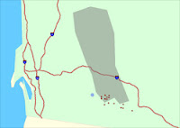
The bottom map is one I have not posted about before. This is the raw WF-HMS data from NOAA. On this map, our home is the blue dot. Their mapping system is not as sophisticated as the one I’ve been showing you maps from, as you can see from cartoonish presentation. One thing that’s particularly confusing is that they use a different map projection system, which has the result that their map appears to be sort of twisted in a clockwise direction by about 20 degrees from the maps you’ve been seeing. Nevertheless, it shows more current WF-HMS data, and it has something in addition: it shows the smoke pattern observed by satellite. And in the case of the Horse Fire, you can easily see that the high-level smoke is moving off mostly to the north.

This will likely be my last post for the evening, unless something dramatic happens. The temperature is cooling off rapidly (75F right now) and the humidity is rising just as quickly (36% right now) — both very good things for the firefighters.

And we are certainly wishing those firefighters well tonight…

Horse Fire IX

The Aqua (EOS PM) satellite, one of those carrying the MODIS imaging equipment, made a pass overhead just before 3 PM. Its view of our area was fairly oblique, as it passed way to the west of us…so the western flanks of the fire may have been invisible to it, as well as anything burning deep in Secret Canyon. It does show a broad area that’s very hot, near the western side of Lake Morena — the furthest part of the Horse Fire from our home…

The darned CDF information line is a bit like playing the slots. Most of the time you just get an old recording. If you’re lucky, you get a human, but they don’t really know very much. If you hit the jackpot — and I just did — you get a human who is well-informed. And even had a sense of humor!

From my jackpot CDF lady I got a good verbal report of the areas still burning (I’ve hand-shaded these purple on the map). The one of most concern to us is the western flank of the fire, and she described an area that jibes nicely with what the survey crew told us. It’s still not an immediate concern for us. She also told us where it’s burning in Secret Canyon; that’s the northernmost purple splotch. It’s also burning on the north and east sides of Lake Barrett — but the honor camp (for dishonorable people) is still safe. And finally, the major burn area is in Bobcat Meadows, just west of the northernmost part of Lake Morena — this jibes nicely with the MODIS data.

The eastern flank of the fire — out near Lake Morena — is still in a wilderness area, but getting closer to civilized areas. I hope they can stop it before it passes Lake Morena, headed east…