Just when you think it’s safe to get a good night of unworried sleep, this darned fire jumps up and slaps you upside the head. A couple of hours ago, everything I could find out sounded like this fire was on its way down.
Now I’m not so sure.
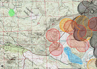
The top map is zoomed out to show the entire fire, with satellite data that’s current as of 6 PM. The green splotch is where our home is. The purple splotch south of the west flank of the fire is a lookout point that we drove to at about 5 PM. To the north and slightly east of that vantage point, I’ve shaded in blue the places where we saw some open flames — not a huge blaze, mind you; more like a collection of bonfires a few hundred feet apart.
The MODIS data (see earlier posts for an explanation of how this data is gathered) shows active spots to the west of Lyons Valley Road for the first time. This is worrisome for us, as it indicates the fire is still burning its way toward us. As we expected, there is activity on MODIS all around the north half of Barrett Lake, and out toward Lake Morena.
The center map, directly at right, shows the same data but zoomed in to show just where our home is and that worrisome western flank of the fire. Again, the green splotch is where our home is, and the blue shaded area is where we saw flames at 5 PM. Those two red MODIS splotches closest to our home is what will keep me from sleeping well tonight…
I called the CDF info line again, and learned that they’re still estimating the burned area at 15,400 acres and just 5% contained. My own estimate, from the satellite data, is that 33 to 39 square miles (22,000 to 25,000 acres) have burned. CDF is reporting lots of assets on the fire: 1,164 people, 17 fire crews, 176 engines, 6 air tankers, 6 helicopters, 6 bulldozers, and 13 water tenders. They also say that the hot, dry weather and rugged terrain are hampering their efforts — of this I have no doubt. But it would be ever so much worse if we had bad winds, and thank goodness we do not.
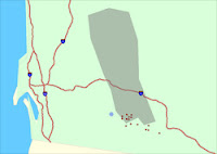
The bottom map is one I have not posted about before. This is the raw WF-HMS data from NOAA. On this map, our home is the blue dot. Their mapping system is not as sophisticated as the one I’ve been showing you maps from, as you can see from cartoonish presentation. One thing that’s particularly confusing is that they use a different map projection system, which has the result that their map appears to be sort of twisted in a clockwise direction by about 20 degrees from the maps you’ve been seeing. Nevertheless, it shows more current WF-HMS data, and it has something in addition: it shows the smoke pattern observed by satellite. And in the case of the Horse Fire, you can easily see that the high-level smoke is moving off mostly to the north.
This will likely be my last post for the evening, unless something dramatic happens. The temperature is cooling off rapidly (75F right now) and the humidity is rising just as quickly (36% right now) — both very good things for the firefighters.
And we are certainly wishing those firefighters well tonight…

No comments:
Post a Comment