When you live (as we do) in chaparral country, you tend to be more conscious of wildfires than most people — for wildfires are an integral part of the natural history of chaparral. I’ve read various estimates of the “natural” (meaning unconstrained by mankind’s actions) interval between wildfires in any given piece of chaparral; they vary from 10 years to 20 years. Most of the native plants in the chaparral have evolved specific mechanisms for dealing with — and taking advantage of — wildfire, especially in germination mechanisms. Many plants will only germinate after a fire, when conditions are perfect (and competition is light) for a new plant.
But of course mankind has come along and completely screwed up the natural cycle — especially fire control. The fact that we put out wildfires (certainly something that any property owner would support!) has two major negative consequences for the chaparral: (1) many chaparral plants (such as manzanita) actually die of old age instead of by fire, and (2) deadwood and brush accumulate incrementally every year, increasing the fuel for the next wildfire. Both of these effects accelerate as the chaparral gets older (e.g., the longer it has been since a wildfire burned it all off).
So, naturally, one of the things that chaparral residents carefully monitor is the “fuel load” that any particular area has. This fuel load is directly related (but non-linearly) to the time that has passed since an area was last burned off. More than 8 or 10 years and an area is at risk; over 15 or 20 years it is at very high risk (and increasing rapidly each year). This is a very general, long-term assessment; in the shorter term the risk in a particular area is more affected by the fuel moisture levels (very dry deadwood can cause a wildfire to almost explode; very damp deadwood, as we have now, makes it difficult for a fire to even get started).
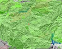
The map at above right (and you really can’t see it unless you click for the larger view) shows the decades that fires have last burned off the areas around our home (the red dot in the middle). Basically what this shows is that most of the area around us has not burned since the 1980s. In fact we know that the area to the east of us (the direction most wildfires come from, driven by the dry, hot Santa Ana winds) has not burned since 1983.
That means we have over 20 years of accumulated fuel surrounding us, for miles and miles, especially to the east. That’s a scary thought, and even scarier when you look at a map of the whole county and see that this is the largest accumulation of fuels left in the county (the Cedar Fire in late 2003 burned off all the other old accumulations). On the positive side, the fire folks have taken notice of this, and have focused considerable energy on this relatively small area of high risk that’s left. They’ve pre-positioned firefighting equipment and have “mastication” projects underway to remove swathes of fuel to form preemptive firebreaks. They’re also more diligent about enforcing brush clearance rules (around buildings), and have been quite public in declaring that their first priority, when it comes to saving buildings, will be for those with adequate clearance around them.
We (and the vast majority of our neighbors) have cleared beyond the minimums around our homes. But, like many others, we have trees near our home that we cherish, both for their beauty and for their shade. In our case, the trees are Italian Stone pine and a couple of different kinds of eucalyptus. Both of these are very vulnerable to fire; basically they will just be torches when this area does burn off. We have several eucalyptus close enough to our house that they could fall on it; this is not a good thing at all. So almost inevitably we’re going to have to take some (and perhaps all) of these trees down, just to get the risk to our house down to an acceptable level. I’ve had this in the back of my mind for several years, always balancing the risk (because of both accumulated fuel and fuel moisture levels) against the benefit of keeping the trees. I came very close to cutting them down this past summer, as the fuel moisture kept going down and down. But the rains finally came before I made up my mind.
I suspect they won’t make it through next summer. Bummer.
