Sunday, July 23, 2006

Horse Fire

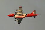
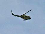
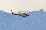
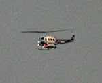
The fire that I posted about earlier today now has an official name: the “Horse Fire” (so called, I presume, because it started in the upper reaches of Horsethief Canyon). According to the last information for this evening, it has now consumed over 6,000 acres and is completely uncontained. During the day there were 4 tanker planes, 4 helicopters, 50 engines, 4 water tenders, 4 bulldozers, and 500 firemen fighting the fire. Now that its after dark, the aircraft have stood down — but the fire crews and all that equipment will be at it all night, in the relative cool and still air. We wish them all well.

This evening, just before dark, Debbie and I, along with Jim (our friend and neighbor), set off on a reconnoiter. This was prompted by the rapid growth of the smoke plume combined an ambiguous CDF message telling us that the fire was burning away from us — but that a community between us and the fire (Carveacre) was “threatened”. This made no sense to us, so we decided to see if we could eyeball it ourselves. The lack of up-to-date and accurate information in these situations is extremely frustrating. On the one hand you’re at risk of life and property from a distant foe; on the other hand you have one heck of a time finding out anything about that foe. The urge to go see it yourself is just about irresistable in those circumstances.

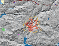
So we went. The map at right has several hand-drawn elements. The green area at left is where our home is. The purple dot near the center is where we were able to drive to (the road was closed further on). The orange circumference is my guess, based on observation from that one point, about the perimeter of the fire (as of about 7pm tonight). The red arrows are my nearly completely uniformed guess about the path of the fire, which has now broken up into numerous fires forming a ragged perimeter. The nearly circular red areas with slanting stripes are areas that showed on MODIS satellite data as having an active fire in them (as of about 11 am).

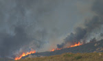
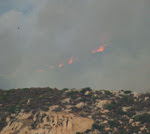
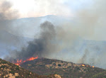
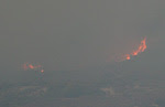
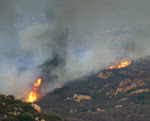
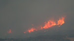
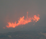
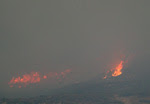
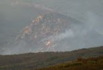
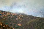
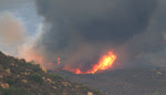
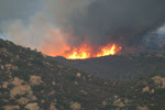
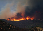
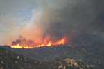
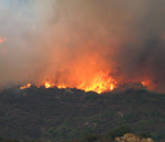
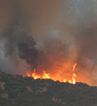
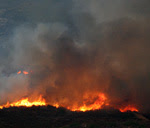
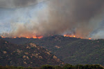
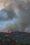
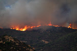
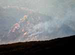
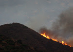
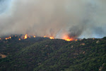
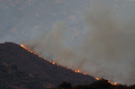
While the scene was dramatic and full of easily observed fires, it was actually quite reassuring. The fire’s center of mass was clearly at a considerable distance (at least a couple miles from where we stood), and much of the terrain between us and it had already been consumed by the fire. There were a few hot spots that were closer, in particular an entire ridge, perhaps a half mile long, that was ablaze just north of Lake Barrett. It seemed to be marching slowly and steadily toward the lake, with no action being taken to stop it. If that fire changed course and headed west, toward Lawson Peak and Gaskill Peak, that would take the fire toward us. There were also a few hotspots visible toward the junction of Lyons Valley Road and Japatul Road; if they broke loose they could also threaten us. But…these were just hotspots, and looked like (to our uneducated eyes) they could be handled by the fire crews. It certainly didn’t look like either Carveacre or Lawson Valley was in imminent danger.

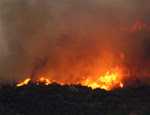
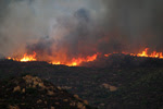
The good news is the same as reported earlier, only much more so because the fire is so much larger now: an enormous swath of the fuel that was such a threat in a Santa Ana condition is now gone. Assuming we survive this one intact, our risk of a catastrophic blaze just got lowered substantially…

I saw something surprising while watching the fire, and was reminded of it as I processed my photos: there were a large number of birds in flight near the fire (I caught quite a few by accident in the photos). Many of the were either raptors, crows, or ravens. I’m guessing that they’re taking advantage of the fire, by hunting the rodents that expose themselves while fleeing the fire. That’s a twist I’d never thought of before. The mice have a choice: stand still and be roasted, or run and be eaten. Once again, for the umpteenth time, I’m very grateful that we humans don’t have to worry much about other animals trying to eat us…

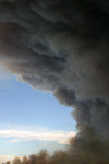
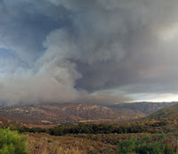
Below are a selection of the bazillion photos I took at the scene. Most of these were taken with a hand-held 620mm lens (stabilized), under very challenging low-light/high-constrast conditions. Please be forgiving of the (many) technical shortcomings — these were not taken in a studio. As usual, click on any thumbnail to get a larger (sometimes much larger!) view…

Fire

Debbie looked out our window about an hour ago and saw a thick column of smoke rising over the mountains, to our east-northeast - a certain indication of a chaparral fire. These fires are a constant worry for us, as we live in an area that hasn’t burned for many years — which means that a huge amount of fuel has built up. Each year when the chaparral gets dry (as happened within the past month), we’re surrounded on all sides by dry, easy-to-ignite, fast-burning fuel. A mental model of five-gallon gasoline cans spaced a few feet apart over the entire landscape isn’t far off the mark…

So we worry when we see smoke on the horizon. And the worry is exacerbated when (as was the case this morning) the wind is blowing that smoke right over our heads — as that means the fire is burning toward us. On the plus side, there’s almost no wind this morning — and wind is the biggest risk factor for brush fires…

On the map at right, our home is in the area marked by a green dot, and the fire took the path shown by the arrow (this is approximate, based on CDF reports). As I write this, the wind has shifted and the fire is now burning toward the northeast, up Horsethief Canyon in the general direction of Pine Valley. This is a completely unpopulated wilderness area that hasn’t burned for over 25 years; access is very limited and the terrain is extremely rugged in many areas. The CDF has numerous aircraft, engines, bulldozers, and ground crews on the fire — a fast response much appreciated by all the locals. And it looks like we can breath easier in this case…the winds are low, blowing the fire away from us, and it seems likely the fire crews will be able to get it under control soon. Helping them is the fact that I-8 is directly in the fire’s path, so they have easy access for all their equipment, should it get that far…

On the plus side, thinking very selfishly: this fire is removing some dangerous fuel that is upwind of us in a Santa Ana condition. The “Santa Anas” are winds we get a few times each year, blowing hot, dry, and hard off the desert, backwards from our normal wind pattern. They are the most dangerous time for fires, because the winds dry out the fuel and push the fires very, very quickly. Both of the big fires that have occurred near us since we moved out to Lawson Valley (the Cedar Fire and the Pines Fire) happened during a Santa Ana. So having some fuel removed in that general direction is a really good thing for us. The 90 degree swath from (about) NE to SE of us is the main danger direction for Santa Anas, and this fire will remove the fuel from about 15 degrees of that, and from only a couple miles away. A few more fires like that and our risk will go down significantly.

Update at 1 PM:

A most unlikely thing is happening: it’s raining! The forecast had a 20% chance for today, but we’ve seen those forecasts so many times — and never any rain — that we just ignore them. I wonder if the rain might have been precipitated by the smoke from the fire? In any case, we got just a small amount of rain, but enough to wet down all the brush — a major risk reduction for us. The CDF news says the fire is still growing, is well-established, and has consumed 300 acres of Horsethief Canyon. It’s still headed away from us…

Update at 3:30 PM:

The rain has stopped — but we got a quarter inch in total. That may not sound like much to those of you living in the green parts of the world, but here in the high desert it’s a veritable flood! I don’t know if it rained on the fire, though…

The image at right is a screen capture of the National Weather Service’s radar image, right at the peak of the rain. The smaller circle to the lower right is a magnified view of our area, centered on our house. You can see that we’re right in the most intense part of the rainfall. To the right of the yellowish high-intensity rain cell that our home is in, you can see a smaller, slightly less-intense cell — that one appears to be right smack over the fire. So maybe they did get some rain on the fire after all!

I called the CDF, and they’re now reporting that it has consumed 500 acres, and is burning in the Pine Canyon wilderness area. They’re listing several communities as “threatened", including Carveacre (which is between the fire and us) and the Barrett Lake Honor Camp (which is full of dishonorable people — go figure). As best I can tell, that means that they haven’t ruled out the possibility of the fire heading west or south, though its currently burning to the east…

The smell of smoke is strong in the air. The wind isn’t blowing the smoke onto us, though high-level air currents, far above ground level, are blowing the smoke plume high overhead. I think the rain fell right through the smoke plume, picking up the smoke particles on the way down. Now outside it is very humid, considerably cooler (in the 70s!), and very strongly smelling of damp smoke…