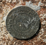
Do you recognize the artifact at right?
It’s a U.S. Coast & Geodetic Survey marker; this particular one on the peak of Cuyamaca Mountain in the San Diego County mountains. It’s a simple bronze disc, three inches (7.5 cm) in diameter, embedded in some permanent and hopefully immovable object. In this case it is embedded in a large rock formation at the summit of Cuyamaca.
There are over one million of these markers in the United States. The vast majority of them were placed long before modern technologies like GPS and laser rangefinders made surveying relatively cheap and easy. The surveyors who placed most of these markers used old-fashioned optical/mechanical surveying instruments, and processes that depended heavily on repetition and cross-checking for accuracy. And these processes were, by today’s standards, almost unbelievably manual. The surveyors walked, hiked, or rode horses to their remote destinations. For the most part, they carried their instruments on their backs. They recorded their observations in log books, in pen-and-ink. And perhaps most amazingly of all, they did all the calculations manually — they couldn’t even use a slide rule, as the precisions they were working with were far higher than were achievable with a slide rule.
The official U.S. Coast and Geodetic Survey started in 1807, and continues to this day (though in a new agency). Thousands of surveyors working for almost 200 years — and these little bronze discs (and the data that records where they are) are perhaps their most important work product.
The little discs are important because they are the starting point of virtually every other survey, whether by government or by private industry. They are the starting point because their absolute position is known more accurately than any other collection of points. Every real estate survey is referenced to one or more of these markers. American cartography is universally traceable back to these markers. Political boundaries (states, counties, cities, etc.) are all traceable to these markers. Pretty important job for a humble little piece of bronze!
Because our hiking (over the past forty plus years) has taken us to many peaks and prominences, we’ve run into many of these markers. Long ago I fell into the habit of searching for them each time I reached a likely looking spot — and more often than not, I’d find one. Sometimes I’d have to brush off dirt and leaves to find it, so I’d know it’s been some number of years since anyone had “visited” that particular marker. On a few occasions, I’ve run into bright, shiny, brandy-new markers — very unexpected, as most of them date back 20 years or more. The oldest one I’ve every spotted was on a peak near Mt. Katahdin in Maine, called “South Brother"; the marker there was dated 1876.
If the story of the American geodetic survey intrigues you, you can find some more information (and pictures) here, here, here, and here.