Tuesday, November 22, 2005

Thanksgiving Shopping

I’m doing the Thanksgiving cooking for us this year, for the first time in several years. I really enjoy cooking, when I have the time to do so; I’m very much looking forward to this. But the first step in Thanksgiving cooking is not usually my favorite: the grocery shopping.

This year the shopping promised to be even more “special” — my injured ankle (healing, but still swollen and sore) didn’t seem likely to make the experience more pleasant. I made the trip down the hill to our local Albertson’s shop, and went to work on my gigantic list.

Amongst the items on this list was one I don’t normally shop for: lard. I cannot remember ever buying lard before. But my apple pie recipe insisted that the crust had to be made with lard, and not shortening, so there it was on my list. But where would it be in the store? I looked first in the meat counter; no dice. Then I looked where the butter and shortening was; it wasn’t there either. So I looked around for a store employee to ask, and spotted a young Hispanic kid with an Albertson’s button. “Can you tell me where you hide the lard?” I asked. With a smile playing on his face (so I knew he was joking), he said “Are you asking me this because I’m Mexican?” And then he led me to the lard, which was with the baking supplies (who knew?). For those of you not familiar with Mexican cooking, it uses a lot of lard…

A few minutes later, I was looking for any kind of turkey scraps that might be available (necks, gizzards, etc.) in the hopes of finding some things that might help make a nice gravy. The same kid was nearby, so I asked him. Without missing a beat, he said “What do you white people do with that stuff?"

This young man’s easy humor and obvious comfort in his own skin (so to speak) really lightened the load I felt on this otherwise not-so-much-fun shopping expedition. Unfortunately my checkout experience wasn’t nearly as nice — the woman immediately in front of me in line wasted 25 minutes of everybody’s time basically trying to scam the store into letting her buy 24 gallons of bleach and 50 boxes of cereal for 50% off — and letting her pay with a check written on a Mexican bank, without her showing any ID at all. She finally left all her bleach and cereal at the counter and stomped out … but only after I had to wait 25 minutes while she attempted her “robbery”.

The kid was much more fun…

Friday, November 18, 2005

Well-Turned Ankle

Lawson Peak is the second-highest peak amongst those surrounding Lawson Valley, where I live. It’s not very high in any absolute sense — just over 3,600' high. But it’s rugged and reasonably remote, and therefore not a trivial challenge. I last hiked to Lawson Peak about 25 years ago, long before I moved into Lawson Valley. But ever since moving here, I’ve wanted to do it again.

Actually we set out today to hike up Gaskill Peak, which at 3,836' is the tallest of these local peaks. With Debi and my friends Jim Barnick and Rick Pugh, we met up at Tyler’s in El Cajon, had a nice breakfast, and then set off to four-wheel up as close as we could get to Gaskill Peak. We went through Alpine to Japatul Road, and thence up Carveacre Road, where there’s a low-density but surprisingly large community developing over the last twenty years or so. Carveacre Road starts out paved, then turns into a gravel road, and deteriorates slowly after that. Once you cross into the Cleveland National Forest (where someone has just installed a gate!), the road clearly hasn’t been maintained in any way for a good many years — it’s actually quite a challenging four-wheel drive road. We made it up to the base of Gaskill Peak (about 800' vertically below it) without mishap, but we failed to find a trail going up. We did locate a trail going down, but this was not our goal.

So we kept going on the four-wheel road until we got to a little saddle, just south of Lawson Peak. The saddle is about 500' vertically below Lawson Peak, making it look like an easy conquest — just a little ways above us. We were thinking that perhaps we’d find a trail along the ridge between Lawson Peak and Gaskill Peak, and we could get up that way. So we parked the car, and set off on our hike.

It started along what looked like another spur of dirt road, but that quickly petered out into an ATV track, then a wide footpath, then, fairly abruptly, a narrow footpath that launched very steeply up over the tumbled-down boulders that form Lawson Peak. Within a short way, Debi (wisely) decided that this wasn’t worth the risk of injury to her — she’s got agility shows coming up soon, and the last thing she needed was to be laid up with a leg or ankle injury. So she took the keys, went back down to our vehicle, and (we found out later) ended up having a nice snooze.

The rest of us, fools that we are, decided to keep on going. Things only got more challenging after that. It’s not that it was dangerous, just that it was hard work — very steep uphill (about a 50% slope, by my map calculations), full of brush and narrow rock gaps, and very large boulders that had to be “conquered” in order to advance. Rick Pugh has long, long limbs, and he’s in great shape compared to me; he had the least trouble. I made it up with much huffing, wheezing, and frequent rests. Jim was somewhere in between.

When we finally made it to the area of the peak, to my disappointment there was no reasonable way up the final pile of large boulders that form the actual peak. I was hoping for a 360 degree panorama; this was not to be. We did manage to edge around the boulder pile to get a clear view — a rather nice one, actually — of Lawson Valley. If you click on the photo above, you’ll get a truly enormous version of this (warning: 4 mb). Lawson Valley is what you see in the right half of the panorama.

From this vantage point I took photos to make up a 180 degree panorama, but I had a great deal of trouble stitching them all together. The software that I use simply wouldn’t let me tack them all together — I managed to exceed some internal (and mysterious) limit that it has. The only way I could get it to stitch was to drop the two photos on each end of the panoram, which means that instead of 180 degrees, I got about 120 degrees. Worse, a nice picture of Rick and Jim hit the cutting room floor; they would have been the “frame” for the left side of the panorama. Oh, well…

The well-turned ankle? That would be mine. I turned it very well — today I’m sitting here at my desk, full of ibuprofen and with my left ankle all wrapped up. Merely putting my foot up to rest on something sends fiery stabs of pain up my leg. Ouch! There are two really bizarre things about this: (1) I’m famous (amongst my hiking friends) for never getting injured like this on hikes, and (2) I didn’t do it on the rugged parts of the hike. Oh, no. I did it a mere 20 feet from our car, as we emerged from the rough stuff onto the almost flat area where we parked our car. A 6” deep, trivial little erosion gully did me in. How embarassing! But it did get me a decent pun <smile>…

On the drive back down, we all more-or-less simultaneously noticed this eroded rock against the skyline. It bears strikingly good resemblence to the head of a squirrel or gopher. It made me want to get out my varmint rifle…

Twelve Words

Now here’s a platform I could get behind:

Win the war.

Confirm the judges.

Cut the taxes.

Control the spending.

That wasn’t so hard, was it, Doctor/Senator/Spineless Politico Frist?

Tip o' the hat to Hugh Hewitt, today’s master of simple and direct language…

Deuce Four's Return

Michael Yon has posted a moving article, with pictures, about the Deuce Four’s return to the U.S.

From Michael Yon’s post:

The overwhelming joy of being home with families and friends was grounded by the permanent losses and severe battle scars of those who paid the highest price for the success of the mission. The ghosts of the fallen took their places alongside widows and family of the fallen comrades.

Just go read it.

Tuesday, November 15, 2005

Tin Foil Hat Brigade

Reading Bruce Schneier’s excellent blog the other day, I happened across this shocker of a post. At first I was sure this was some elaborate joke on the part of some MIT students — hi-brow hi-jinks. Now I’m not so sure, as the study looks like it could be serious. It starts:

Abstract of On the Effectiveness of Aluminium Foil Helmets: An Empirical Study:

Among a fringe community of paranoids, aluminum helmets serve as the protective measure of choice against invasive radio signals. We investigate the efficacy of three aluminum helmet designs on a sample group of four individuals. Using a $250,000 network analyser, we find that although on average all helmets attenuate invasive radio frequencies in either directions (either emanating from an outside source, or emanating from the cranium of the subject), certain frequencies are in fact greatly amplified. These amplified frequencies coincide with radio bands reserved for government use according to the Federal Communication Commission (FCC). Statistical evidence suggests the use of helmets may in fact enhance the government’s invasive abilities. We speculate that the government may in fact have started the helmet craze for this reason.

Gotta love that “speculation"! Here’s their conclusion:

Conclusion

The helmets amplify frequency bands that coincide with those allocated to the US government between 1.2 Ghz and 1.4 Ghz. According to the FCC, These bands are supposedly reserved for ''radio location'' (ie, GPS), and other communications with satellites (see, for example, [3]). The 2.6 Ghz band coincides with mobile phone technology. Though not affiliated by government, these bands are at the hands of multinational corporations.

It requires no stretch of the imagination to conclude that the current helmet craze is likely to have been propagated by the Government, possibly with the involvement of the FCC. We hope this report will encourage the paranoid community to develop improved helmet designs to avoid falling prey to these shortcomings.

As Bruce points out (how does he find out about these things?), there is a rebuttal to the study. Here’s a sample of that:

First and foremost, Rahimi et al. only considered simple radio frequencies. As I explained in detail in chapter 4 ("Psychotronic and AFDB Theory") of my book, only psychotronic energy can affect the brain in any coherent manner. Simple EM fields have only trivial effects — such as causing indistinct sensations of a supernatural presence — over short distances. Only by converting electromagnetic energy into psychotronic energy using a psychotron-based device can the forces of mind control access from afar the neural network of a brain to both implant and extract thought complexes.

[FIGURE 1 appears here]

FIGURE 1: An AFDB-covered brain (A) is shielded by a repulsive resonance buffer (B), which deflects psychotronic fields (C). Coherent psychotronic rays (D) are defected at the aluminum surface (E) and decoherently scattered (F). The resonance buffer encapsulates the brain (G), providing basal protection against fields and glancing rays.

As illustrated in Figure 1, unlike with the mere attenuation of EM fields, aluminum deflects psychotronic fields and coherent psychotronic rays. The operational modalities of AFDBs for EM and psychotronic energies are completely different, and thus the experiment conducted by Rahimi et al. is inappropriate to test the effectiveness of deflector beanie technology in stopping mind control.

Oh, my. Psychotronic rays? Deflector beanie technology? Repulsive resonance buffers?

Either (a) the author of the rebuttal has made a marvelous piece of satire, or (b) evolution isn’t quite as effective as I’d hoped. The author is Lyle Zapato; after a little bit of poking around his site, I found this mission statement:

"End subjugation of humanity under Entropic yoke of clandestine and/or paraterrestrial agencies through technological, informational, and spiritual empowerment of individuals employing, but not exploiting, the synergistic leveraging of enterprise level subversion."

I’m pretty sure that’s satire <smile>…

I also had to go take an aspirin to relieve the belly pain derived from laughing so hard at some of his posts. Try “Belgium Doesn’t Exist!” for starters.

Anyway, I’m relieved to be able to say that Zapato’s rebuttal is clearly satire. Now if only I was so certain about the original study…

Oh, and one last thing. One of Bruce’s commenters says:

For those of you who think this is a “Waste of Resources"

This is obviously a couple of grad students playing around and having fun and producing something suitable for the AIR (Annals of Improbable Resource) and/or the Ig nobel prize.

So they go borrow a little equipment and have fun. (Yeah, the equipment was expensive. But if it wasn’t being used at the time, its value is actually negative (it’s depreciating without benefit))

Research in this line is the same as “Is Kansas Flatter than a Pancake” (the answer: YES). Also, one could argue that some interesting research has been produced by such studies, such as the “Sex in MRI machine” study, which actually revealed some interesting results about human anatomy, but seems to have been done on a lark.

This seems totally on point to me. But now I want to know about that “Sex in MRI machine” study!

Dione and Tethys

Every once in a while, as Cassini whizzes around Saturn on its mission of exploration, two or three of the many moons of Saturn will line up in an interesting way (from Cassini’s vantage point). This photo capture two of the major moons in just such a lineup.

Dione is slightly larger than Tethys, and in this picture it’s just over half the distance away from Cassini. The rings, with the Cassini division, are seen nearly edge on.

From the Cassini web site:

The moons Dione and Tethys face each other across the gulf of Saturn’s rings. Here, the Cassini spacecraft looks on the Saturn-facing hemisphere of Tethys below and the anti-Saturn side of Dione above. The dark groove in the rings is the Cassini Division.

Tethys is 1,071 kilometers (665 miles) across, while Dione is 1,126 kilometers (700 miles) across.

This image was taken in visible light with the Cassini spacecraft narrow-angle camera on Sept. 22, 2005, at a distance of approximately 860,000 kilometers (530,000 miles) from Dione. Tethys was on the far side of the rings, 1.5 million kilometers (900,000 miles) from Cassini. The image scale is 5 kilometers (3 miles) per pixel on Dione and 9 kilometers (6 miles) per pixel on Tethys.

Monday, November 14, 2005

Elk Steaks

My parents live in New Jersey (yeah, I know — but at least they don’t live in North Jersey!), and their friend and neighbor Paul Bruni sends this report on his recent elk hunting trip in the western U.S.:

Unfortunately elk steaks will not be on the Bruni menu this year! A lack of shooting accuracy is the apparent cause of this shortage. However, in defense of the shooter from NJ, where a two hundred yard shot is considered long, these shots were extremely long. The six missed shots ranged from three hundred yards to five hundred plus yards. At that range, the characteristics of the bullet’s trajectory can be tricky and dramatic. In other words, I missed!

I saw six bulls (that’s elk talk) and no cows (that’s elk talk too), and got six shots at four of them. No one else got a shot and some guys didn’t see elks, period. I am satisfied with my first attempt at something that was much more than just a “kill” for me.

This was a real western, cowboy and somewhat dangerous experience that I will never forget. From the location of the base camp to the areas we horse backed to and hunted, up to five miles, the scenery was spectacular and the air was very thin. We hunted at ten thousand feet with camp at nine. WOW, we were wakened at four a.m. as the guide re-lights the fire in the pot belly stove. Head to the food tent and have a great breakfast. By five a.m. saddle up and off you go into the darkness. Thank god for the horses, my new favorite animal. You look up and see more stars than you have every seen before! It was incredible. After hunting all day, we would return, in the dark and have a great dinner prepared by the cook Debbie. Some good conversation follows and then back to our tent. It consisted of a dirt floor, a bucket and a pan for plumbing, a pot belly stove for heat and a Coleman lantern for light! There, much of the conversation was, “what am I doing here and how in the hell did the Indians live like this?” Now we know why their population stayed so high! But, we were without squaws. We had only each other, our horse or a mule named Amos.

My roommate (tent mate) drank a lot of beer thank god. He got up to pee frequently enough to maintain a decent fire. But getting out of a sleeping bag and trotting outside, in ten degree weather to pee is the PITS! There were no phones, no computers and no human interaction other than that of the camp. I loved it!

It’s nice to be back home though.

I think Paul needs some practice at this “great outdoors” stuff <smile>. I especially liked his reaction to waking at 4 AM, and his thoughts about Amos in the absence of “squaws”.

And Paul: I really hate to break this to you, but … the Indians didn’t have buckets, pot-bellied stoves, or Coleman lanterns!

Friday, November 11, 2005

Remember Them

Take a moment today to ponder the magnificent courage our veterans have shown — and the sacrifices they’ve made — that allow us to enjoy the marvelous freedom and safety that we have. I stand in humbled awe of our warriors, both of the glorious past and the equally glorious present. And if you see a member of our armed forces today … take a moment to thank them.

Those who know me well know that I am nearly perfectly immune to the allure of poetry. So you may be surprised to see a poem reproduced here. But the poem below, which I first encountered 30+ years ago when it was read at a U.S. Navy Veterans Day commemoration, has always been able to bring a tear to my eyes.

And the photo at right — what can I say that the photo does not aleady say far more eloquently?

FOR THE FALLEN

With proud thanksgiving, a mother for her children

England mourns for her dead across the sea,

Flesh of her flesh they were, spirit of her spirit,

Fallen in the cause of the free.

...

Solemn the drums thrill: Death august and royal

Sings sorrow up into immortal spheres,

There is music in the midst of desolation

And glory that shines upon our tears.

...

They went with songs to the battle, they were young,

Straight of limb, true of eyes, steady and aglow,

They were staunch to the end against odds uncounted,

They fell with their faces to the foe.

...

They shall grow not old, as we that are left grow old:

Age shall not weary them, nor the years condemn

At the going down of the sun and in the morning

We will remember them.

...

They mingle not with their laughing comrades again,

They sit no more at familiar tables of home,

They have no lot in our labour of the daytime,

They sleep beyond England’s foam.

...

But where our desires and hopes profound,

Felt as a well-spring that is hidden from sight,

To the innermost heart of their own land they are known

As the stars are known to the night.

...

As the stars shall be bright when we are dust,

Moving in marches upon the heavenly plain,

As the stars that are stary in the time of our darkness,

To the end, to the end, they remain.

...

Laurence Binyon, 1914

We will remember them.

Thursday, November 10, 2005

Geodetic Survey

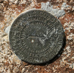
Do you recognize the artifact at right?

It’s a U.S. Coast & Geodetic Survey marker; this particular one on the peak of Cuyamaca Mountain in the San Diego County mountains. It’s a simple bronze disc, three inches (7.5 cm) in diameter, embedded in some permanent and hopefully immovable object. In this case it is embedded in a large rock formation at the summit of Cuyamaca.

There are over one million of these markers in the United States. The vast majority of them were placed long before modern technologies like GPS and laser rangefinders made surveying relatively cheap and easy. The surveyors who placed most of these markers used old-fashioned optical/mechanical surveying instruments, and processes that depended heavily on repetition and cross-checking for accuracy. And these processes were, by today’s standards, almost unbelievably manual. The surveyors walked, hiked, or rode horses to their remote destinations. For the most part, they carried their instruments on their backs. They recorded their observations in log books, in pen-and-ink. And perhaps most amazingly of all, they did all the calculations manually — they couldn’t even use a slide rule, as the precisions they were working with were far higher than were achievable with a slide rule.

The official U.S. Coast and Geodetic Survey started in 1807, and continues to this day (though in a new agency). Thousands of surveyors working for almost 200 years — and these little bronze discs (and the data that records where they are) are perhaps their most important work product.

The little discs are important because they are the starting point of virtually every other survey, whether by government or by private industry. They are the starting point because their absolute position is known more accurately than any other collection of points. Every real estate survey is referenced to one or more of these markers. American cartography is universally traceable back to these markers. Political boundaries (states, counties, cities, etc.) are all traceable to these markers. Pretty important job for a humble little piece of bronze!

Because our hiking (over the past forty plus years) has taken us to many peaks and prominences, we’ve run into many of these markers. Long ago I fell into the habit of searching for them each time I reached a likely looking spot — and more often than not, I’d find one. Sometimes I’d have to brush off dirt and leaves to find it, so I’d know it’s been some number of years since anyone had “visited” that particular marker. On a few occasions, I’ve run into bright, shiny, brandy-new markers — very unexpected, as most of them date back 20 years or more. The oldest one I’ve every spotted was on a peak near Mt. Katahdin in Maine, called “South Brother"; the marker there was dated 1876.

If the story of the American geodetic survey intrigues you, you can find some more information (and pictures) here, here, here, and here.

Cuyamaca Autumn

These are some more photos from the hike that Debi and I made up Cuyamaca Peak this past Sunday. As usual, clicking on any of the will bring up a larger view.

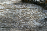
The images in the top row all show some aspect of the destruction wrought by the fire. The two outer ones are obviously charred logs; the center one is a dead oak, it’s bark burned by the fire so badly that it sloughed off. What you’re seeing is the wood immediately under the bark, with the characteristic oak texture (lots of pores) clearly visible, along with the trails of some insect that ate its way along trails just under the bark. Presumably the bugs were well toasted in the fire!

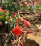
The second row are the autumn flowers, of which there are a dozen or so species in bloom presently. They made beautiful splashes of color, contrasted against the somber autumn tones and the stark blacks and grays left by the fire. I don’t know what any of these flowers are.

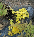
The bottom row is the kind of thing folks in other climates see very commonly: the “fall color” of the leaves of deciduous trees. We have it here in southern California as well, but not with anything remotely resembling the wild abundance of color that is the norm in places like New England or the Appalachians. But we cherish what we have…

Everest on Mars

Spirit and Opportunity — the extraordinarily successful mobile probes on Mars — have now been operating for very close to two years. Not bad at all for missions designed to last just three months!

Recently Spirit climbed to the top of the Columbia Hills, and on a peak the scientists at JPL have named “Everest", the Spirit probe paused to take this 360 degree panorama of the spectacular view it was enjoying. You can click on the image at right to get a slighly larger view — or you can go to the rover site to get a truly enormous (40+ MB!) version, nearly big enough to wallpaper your livingroom with.

I’ve repeated this so many times I’m sure my long-timer readers are bored to hear it again, but … these two probes are making manned space exploration (at least as it’s currently practiced) look like a positively silly waste of time, energy, and money. And they’re not alone — Spirit and Opportunity have dozens of “brothers” and “sisters", like Cassini-Huygens around Saturn, the Hayabusa probe, and many more. Many of those probes all by themselves are producing more good, hard, useful science results than all of the manned space missions combined. And they’re doing it for one helluva lot less moolah…

Wednesday, November 9, 2005

Blue Morning

What an unpleasant way to start my morning — by discovering that every single one of the propositions championed by Governor Arnold Schwartzenegger has been defeated at the polls. This is a tremendous victory to big-money, big-union, status quo politics, and a big blow for common sense and honest democracy.

Unless something happens (but what?) to shock liberal Californians to their senses, I suspect we’re stuck with at least several more years of profoundly corrupt and ineffective local politics…

Tuesday, November 8, 2005

Recovery

The hike Debi and I made up Cuyamaca Mountain on Sunday (see two preceding posts) had some unanticipated moments of beauty. In the two years that have passed since the Cedar Fire, the ground-dwelling flora have been growing luxuriantly. Between the nutrients added by the fire, the exposure to sunlight now that the forest is basically gone, the wet year we had this year, and the fact that many of these plants have evolved to take advantage of the fire’s aftermath, happy days are here again for these plants!

At the 5,000 to 6,000 foot level, where these pictures were taken, there apparently has been a hard frost some weeks ago. In the top row of photos (click on any of them for a larger view) the brown tones are dominated by ferns; in the lower row it’s other plants I have not identified. I thought the contrast and textures of the charred trees was interesting; certainly not what we would ordinarily see on an autumn hike like this…

Cuyamaca

As I mentioned in the post below, Debi and I had a very enjoyable hike up to Cuyamaca Peak this past Sunday. On the “shoulder” of the mountain, just before the last push up to the peak, is one of our favorite spots from our many hikes this way in the past. It’s a small meadow that extends partway down the western flanks of Cuyamaca Mountain, and the absence of trees combined with the altitude makes for a wonderful view.

The panorama at right was stitched together from three individual pictures, taken handheld. Even in the small version (click for a much larger one) you can see the skeletons of the sparse trees. But when you look in this direction from Cuyamaca, you’re looking at that enormous area that the Cedar Fire completely burned off — and it was very evident on Sunday. The normal tones of chaparral in the autumn were all “off”. In some areas, the greys of the ashes and tree skeletons show through even at a distance of miles. Everywhere the colors are altered by the absence of the normal chaparral growth. A very somber perspective, indeed…

Happy Dogs

Debi and I took a hike on Sunday that we haven’t made for over two years — up the “fire road” to Cuyamaca Peak from Paso Picacho campground in Cuyamaca State Park. We’ve avoided this area, for the most part, ever since the terrible Cedar Fire in October 2003 that burned the beautiful old forests that we loved so much. Just driving through the park, as we have on numerous occasions since the fire, is enough to make me heartsick and depressed.

The hike turned out to more interesting and less depressing than I expected. Yes, the walk takes you through nearly three miles of nearly completely devastated forest. But unexpectedly, near the peak, there is a substantial area of surviving old-growth forest with a lot of different species represented. Perhaps these individuals will be the parent stock for the native species return. We saw conifer seedlings — something we’ve missed at lower altitudes in previous hikes. We also saw manzanitas seedlings (abundantly) and mind-boggling quantities of ceanothus (assuming I’ve identified it correctly), currently two to three feet high. That mountainside is going to be something spectacular when the ceanothus is old enough to bloom!

To our dogs (Mo’i on the left, Lea on the right), however, this was just one giant super-walkie. They were so happy to be out with us for several hours of sustained walking — it just doesn’t get any better than that if you’re of the canine persuasion…

We stopped on the way home for a late lunch at the Descanso Junction restaurant. This little place is quickly becoming a favorite of ours — inexpensive, and unpretentious, but just plain delicious home-style cooking. I highly recommend their Philly steak sandwich — especially if you add mushrooms to their standard offering (and they’re happy to do that). Debi had a steak salad that featured a perfectly cooked-to-order piece of beef that was a significant chunk of the bovine donor. And Debi’s facial expressions, grunts, and moans of delight, plus the fact that she left nary a molecule on her plate, told me that she was very happy with her meal, too…

Monday, November 7, 2005

Just Wondering

These important questions arrived in yesterday’s email:

Can you cry under water?

How important does a person have to be before they are considered assassinated instead of just murdered?

If money doesn’t grow on trees then why do banks have branches?

Since bread is square, then why is sandwich meat round?

Why do you have to “put your two cents in"… but it’s only a “penny for your thoughts"? Where’s that extra penny going to?

Once you’re in heaven, do you get stuck wearing the clothes you were buried in for eternity?

Why does a round pizza come in a square box?

What disease did cured ham actually have?

How is it that we put man on the moon before we figured out it would be a good idea to put wheels on luggage?

Why is it that people say they “slept like a baby” when babies wake up like every two hours?

If a deaf person has to go to court, is it still called a hearing?

If you drink Pepsi at work in the Coke factory, will they fire you?

Why are you IN a movie, but you’re ON TV?

Why do people pay to go up tall buildings and then put money in binoculars to look at things on the ground?

How come we choose from just two people for President and fifty for Miss America?

Why do doctors leave the room while you change? They’re going to see you naked anyway.

If a 911 operator has a heart attack, whom does he/she call?

Why is “bra” singular and “panties” plural?

Do illiterate people get the full effect of Alphabet soup?

Who was the first person to look at a cow and say, “I think I’ll squeeze these dangly things here, and drink whatever comes out!"

Why do toasters always have a setting that burns the toast to a horrible crisp, which no decent human being would eat?

Why is there a light in the fridge and not in the freezer?

When your photo is taken for your driver’s license, why do they tell you to smile? If you are stopped by the police and asked for your license, are you going to be smiling?

If Jimmy cracks corn and no one cares, why is there a stupid song about him?

Can a hearse carrying a corpse drive in the carpool lane?

If the professor on Gilligan’s Island can make a radio out of a coconut, why can’t he fix a hole in a boat?

Why do people point to their wrist when asking for the time, but don’t point to their crotch when they ask where the bathroom is?

Why does Goofy stand erect while Pluto remains on all fours? They’re both dogs!

What do you call male ballerinas?

Can blind people see their dreams? Do they dream?

If Wyle E. Coyote had enough money to buy all that ACME stuff, why didn’t he just buy dinner?

If corn oil is made from corn, and vegetable oil is made from vegetables, what is baby oil made from?

If electricity comes from electrons, does morality come from morons?

Is Disney World the only people trap operated by a mouse?

Do the Alphabet song and Twinkle, Twinkle Little Star have the same tune?

Why did you just try singing the two songs above?

Why do they call it an asteroid when it’s outside the hemisphere, but call it a hemorrhoid when it’s in your butt?

Did you ever notice that when you blow in a dog’s face, he gets mad at you, but when you take him for a car ride; he sticks his head out the window?

Do you ever wonder why you gave me your e-mail address in the first place?

Hat tip to John & Grayle Blecker

Landmarks

As we walk through the hills around our home, we see the scene around us change every few minutes. Familiar landmarks move around, change perspective and shape, appear and disappear. Probably the most evident aspect of the scene around us is the horizon and the peaks that shape it. I took the panorama at right on yesterday morning’s walk, just to illustrate this phenomenon. The five most promienent peaks are labeled on the photo (click at right to bring up a large view).

Gaskill Peak and Lawson Peak are part of the mountains that surround Lawson Valley (where we live). They are visible on our entire mile-long hike, though their relative position changes quite dramatically. Viejas Mountain is also visible the entire time, but here you see much more of it than you would from our house (which is 400 or 500 feet lower in elevation). But Cajon Mountain and Cuyamaca Peak are not visible at all from our home. They appear, bit by bit, as we hike up the hill.

Before GPS, these clearly visible, well-defined peaks would have made wonderful landmarks to use with a compass, topographic map, and protractor to figure out exactly where you were. I’ve done this as an exercise, and it’s pretty easy to locate yourself with an accuracy of 50 feet or so — nearly as good as the GPS (without WAAS). But the old-fashioned way sure is a lot more work! The information that comes effortlessly from the GPS can only be duplicated with 5 or 10 minutes of concentrated work.

Meanwhile, we’ll just enjoy the shifting scenery on our walk…

Sunday, November 6, 2005

Sexy in New Jersey?

Skippy (who hasn’t had sex for 220 days!) at Enjoy Every Sandwich, takes a look at the New Jersey gubenatorial race:

As we all know, there’s a gubenatorial election in the Graden State on Tuesday. Well, we all know it, but very few of us actually care. This race is essentially over and has been for a year. Ever since he announced his candidacy, it has been a forgone conclusion that US Senator and trazilionaire Jon Corzine will soon be custodian of the world’s largest garbage dump.

The worst part is that the race couldn’t have been more boring. Maybe I’ve been spoiled by Jersey politics, controlled as it is by a cabal of sundry Sopranos and barely closeted homosexuals who realize their “truth” in their fifties.

If you can handle Skippy’s very direct and unihibited writing style, the rest of his post is hysterically funny. Especially if you’re from New Jersey, or (like me) an escapee from New Jersey…

Thursday, November 3, 2005

Fan Behavior

I’m working on an electronic design that includes a fan to exhaust warm air, and a filter on the air intake to keep the electronics from getting covered in dust. The finished project will be placed in a somewhat dirty room that is quite remote from where I will be monitoring the equipment. I want to sense whether the filter is dirty enough to restrict air flow. Of course I can (and will be) monitoring temperatures, but I’m looking for something that’s a more direct measure of air flow.

I had an idea: that there should be a difference in fan speed between a clean filter and a dirty filter. The fan speed should go down, I thought, if the filter was clogged up (as it would be working harder, kind of like a car going uphill). So I decided to test this thought out. I connected a small fan (an 80 mm “case fan") to 12 VDC, and monitored its RPM. Sitting on my desk, this fan rotated at just under 4,500 RPM. Then I put a piece of cardboard across the intake side of the fan, expecting the RPM to go down, though I didn’t know by how much. The RPM with the cardboard completely blocking the intake was 4,700 RPM — it went up! This effect was completely repeatable…

Does anyone know the explanation for this?

Flaming Paris

For the past seven nights in a row, Paris has been burning. You’d never know it from the MSM, but riots and other disturbances have been steadily escalating. Last night, over 100 cars were burned, a shopping center set ablaze and destroyed, people were injured, public and private property vandalized, and even a police station briefly taken over. French politicians are in full crisis mode, right up to Chirac. Gateway Pundit has been running a series of must-read posts on these events. The rioters are Islamic youths, primarily young men. The excuse: the deaths of two teenagers a week ago, electrocuted, we’re told, as they fled from police.

What’s really going on?

I have no personal knowledge of the situation in Paris, but I have researched several dozen sources over the past week. I was taken by surprise by the riots in Paris, so I wanted to understand how such a thing could happen. After all this research, I conclude there are two major factors underlying the explosion of violence in Paris:

1. French policies that discourage integration of immigrant communities, and encourage the development of “enclaves” of foreign culture. These policies almost certainly derive from widely held racist views, no matter how the French intellectuals dress them up. For example, European elites, in talking about the Islamic ghettos that dot the European scene, will pat themselves on the back and say things like: “We’re sooooo superior to the U.S. — we’re tolerant of the Islamic culture here, and we let them freely recreate these islands of Islamic culture within Europe.” Really? Here’s another view (mine): you’re all smug racists, convinced of your own superiority (over everybody, including Muslims and Americans), and the only way you’re going to tolerate alien cultures and ways of thinking is to bottle them all up in some place where they won’t offend your sense of propriety. Like a nice Islamic slum.

2. French economic policies, resulting in very few available jobs (which go first to the “real” Frenchmen, of course) and a massive public dole. The direct result of these policies is a large unemployed population in the isolated immigrant communities — people with no way up, no incentive to leave, and lots of anger. If you wanted to design a volatile situation, this might be what you end up with.

So what’s the answer? Darned if I know! I suppose it’s possible that somehow the French people will wake up some day, and take some concrete action to deal with the situation. But who knows what that action would be? I’m not sure we’d like it all that much. For instance, suppose their reaction was to throw all the Islamic people out of France? That’s millions of people at this point…we’d have a massive humanitarian problem then, and of course the anger and volatility of the situation would only increase. I can imagine good outcomes as well, though they don’t seem very likely: the French could vote out their entire corrupt government and replace it with an honest, pragmatic one. I don’t think I’ll live that long <smile>…

If there’s any good in this situation at all, it’s this: events like this are probably the only thing that could shock the European people and political structure into actually helping America in the war on terror…