
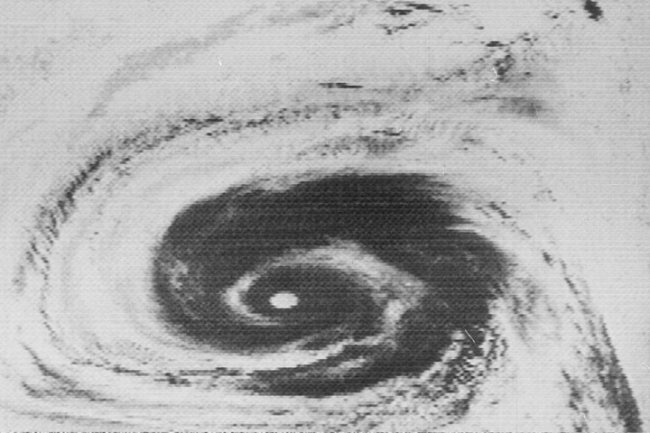
Just a couple of weeks before my twelfth birthday (just over 50 years ago), the U.S. launched Nimbus 1 and changed all that. Nimbus 1 was the first weather satellite with electronic image transmission capability, and over its lifetime it sent back thousands of images like the grainy hurricane photo above right. Its photos weren't the first satellite weather photos, but it was the first satellite that provided continuous coverage. At first it was most of the Earth's surface, then as more satellites were launched, it became 24 x 7 coverage of the entire Earth's surface.
It's hard to imagine, these days, just what a revolution that was. Prior to Nimbus, it was entirely normal for major weather events (like hurricanes, typhoons, or tropical storms) to strike by surprise, with little or no warning. The oceans and unpopulated land areas of earth are so vast that one of these things could easily form with no instruments around to see or track it. With the advent of Nimbus, such surprises suddenly were banished. A surprise hurricane simply couldn't happen today – all the eyes in the sky would see it long before it even reached hurricane status.
As with many things these days, once again I marvel at the advances in technology just over the course of my own life. When I was born, our ability to observe the Earth's weather was like someone trying to figure out New York City from a perch on top of the Empire State Building, able to observe only a few things while the sun is up. Today it's as though we have instruments on every street corner, seeing absolutely everything that's happening on every street, day and night.
The capabilities of the (now many) weather satellites are something we all take for granted. These days the satellites capture much more than images: they observe surface and atmospheric temperatures (at many elevations), winds, waves, atmospheric gases, polar ice, water levels, and much more. Satellites aren't the only weather-related technology marvels, either. Some other examples: the weather radars that cover much of the U.S. (and many other countries), the tens of thousands of amateur weather stations that are connected in vast realtime weather data networks, and the robotic underwater explorers that measure undersea salinity and temperature over vast stretches of our oceans. All of these, and much more, have been developed in just the past fifty years...
And with all the eyes in the sky and such they still can't find flight MH370. They should probably just pick up the phone and call the NSA.
ReplyDelete