

Debbie looked out our window about an hour ago and saw a thick column of smoke rising over the mountains, to our east-northeast - a certain indication of a chaparral fire. These fires are a constant worry for us, as we live in an area that hasn’t burned for many years — which means that a huge amount of fuel has built up. Each year when the chaparral gets dry (as happened within the past month), we’re surrounded on all sides by dry, easy-to-ignite, fast-burning fuel. A mental model of five-gallon gasoline cans spaced a few feet apart over the entire landscape isn’t far off the mark…
So we worry when we see smoke on the horizon. And the worry is exacerbated when (as was the case this morning) the wind is blowing that smoke right over our heads — as that means the fire is burning toward us. On the plus side, there’s almost no wind this morning — and wind is the biggest risk factor for brush fires…
On the map at right, our home is in the area marked by a green dot, and the fire took the path shown by the arrow (this is approximate, based on CDF reports). As I write this, the wind has shifted and the fire is now burning toward the northeast, up Horsethief Canyon in the general direction of Pine Valley. This is a completely unpopulated wilderness area that hasn’t burned for over 25 years; access is very limited and the terrain is extremely rugged in many areas. The CDF has numerous aircraft, engines, bulldozers, and ground crews on the fire — a fast response much appreciated by all the locals. And it looks like we can breath easier in this case…the winds are low, blowing the fire away from us, and it seems likely the fire crews will be able to get it under control soon. Helping them is the fact that I-8 is directly in the fire’s path, so they have easy access for all their equipment, should it get that far…
On the plus side, thinking very selfishly: this fire is removing some dangerous fuel that is upwind of us in a Santa Ana condition. The “Santa Anas” are winds we get a few times each year, blowing hot, dry, and hard off the desert, backwards from our normal wind pattern. They are the most dangerous time for fires, because the winds dry out the fuel and push the fires very, very quickly. Both of the big fires that have occurred near us since we moved out to Lawson Valley (the Cedar Fire and the Pines Fire) happened during a Santa Ana. So having some fuel removed in that general direction is a really good thing for us. The 90 degree swath from (about) NE to SE of us is the main danger direction for Santa Anas, and this fire will remove the fuel from about 15 degrees of that, and from only a couple miles away. A few more fires like that and our risk will go down significantly.
Update at 1 PM:
A most unlikely thing is happening: it’s raining! The forecast had a 20% chance for today, but we’ve seen those forecasts so many times — and never any rain — that we just ignore them. I wonder if the rain might have been precipitated by the smoke from the fire? In any case, we got just a small amount of rain, but enough to wet down all the brush — a major risk reduction for us. The CDF news says the fire is still growing, is well-established, and has consumed 300 acres of Horsethief Canyon. It’s still headed away from us…
Update at 3:30 PM: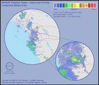
The rain has stopped — but we got a quarter inch in total. That may not sound like much to those of you living in the green parts of the world, but here in the high desert it’s a veritable flood! I don’t know if it rained on the fire, though…
The image at right is a screen capture of the National Weather Service’s radar image, right at the peak of the rain. The smaller circle to the lower right is a magnified view of our area, centered on our house. You can see that we’re right in the most intense part of the rainfall. To the right of the yellowish high-intensity rain cell that our home is in, you can see a smaller, slightly less-intense cell — that one appears to be right smack over the fire. So maybe they did get some rain on the fire after all!
I called the CDF, and they’re now reporting that it has consumed 500 acres, and is burning in the Pine Canyon wilderness area. They’re listing several communities as “threatened", including Carveacre (which is between the fire and us) and the Barrett Lake Honor Camp (which is full of dishonorable people — go figure). As best I can tell, that means that they haven’t ruled out the possibility of the fire heading west or south, though its currently burning to the east…
The smell of smoke is strong in the air. The wind isn’t blowing the smoke onto us, though high-level air currents, far above ground level, are blowing the smoke plume high overhead. I think the rain fell right through the smoke plume, picking up the smoke particles on the way down. Now outside it is very humid, considerably cooler (in the 70s!), and very strongly smelling of damp smoke…
No comments:
Post a Comment