
Unbeknownst to me, UCSD and USD have been collaborating on a project called High Performance Wireless Research and Education Network (or HPWREN) for a while now. HPWREN has several interesting capabilities, some of which were put to good use during the recent Horse Fire. That last link has some terrific “movies” made from still pictures taken at intervals of a couple of minutes, showing the progress of the Horse Fire.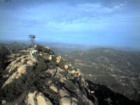
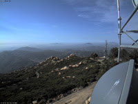
But the most interesting discovery for me is that HPWREN has several near-realtime web cameras (they update every two minutes) mounted on good vantage points around the county — and one of them is just a couple miles south of me, on Lyons Peak. This camera is actually four cameras in one, with each camera centered on a compass cardinal point and viewing a quadrant. The pictures at right I captured just before posting this; they show north and east views. My home is out of sight, just right of center in the left hand photo. The bulk of the Horse Fire was between Barrett Lake and Lake Morena, nearly dead-center in the right hand photo. These two cameras in particular would have been very useful (and in hindsight, very comforting) during the Horse Fire.
I’ve written to the folks at HPWREN to see if there may be ways we can collaborate to make JamulBlog an even better wildfire resource for Jamulians. I’ll let you know what they have to say…
Tip of the hat to “atr” for this excellent information!
No comments:
Post a Comment