

Several of my readers have emailed to ask me how on earth I could possibly see anything good coming out of the Horse Fire. One of them (who shall remain unnamed) even accused me of being around-the-bend insane. This is an attempt to defend my sanity.
These maps show a larger area than the recent maps I’ve published. In both of these, there’s a purple square in the area where our home is, just to the left of center.
The upper map has pinkish areas that show all the areas burned in fires that occurred from 2000 through 2005. Those pink areas are the least likely to burn again within the next few years, because much of the fuel is gone. I’ve driven through those pink areas to the northwest of our home within the past few weeks — and even though that fire was in 2001, five years ago, there’s still very little fuel there.
But if you start with that purple square, and look at the 90 degree swath of land from about NE to about SE, you’ll see that there’s virtually nothing that’s burned within the past six years — for miles and miles and miles. During a Santa Ana wind condition, that’s the direction the winds are coming from — so any fire that started out in that direction during a Santa Ana would pose a big risk to us.
Now if you look at what the Horse Fire has done, you’ll see that it has reduced the aperture of risk considerably. Any fire starting to the east of the Horse Fire’s area will have to go around that burned area to get us. It’s still not impossible for it to do so, of course — but it’s definitely going to slow such a fire down, and remove a whole bunch of fuel that could have made it grow.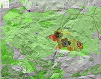
The lower map (at right) shows different green shadings for fires in the decades between 1950 and 1999. Most of that map is covered by an area burned in 1972. All of Lawson Valley, including where our house now stands, was burned that year. We’re living amidst 34 years of fuel accumulation — and that’s the same kind of accumulation that the Horse Fire is now burning in.
The most relevant thing visible on this map is due south of the Horse Fire, where there’s an area of about the same size as the fire that isn’t burned on either of these two maps. That means that there’s over 50 years of fuel accumulated in that area — making it the biggest risk area left anywhere near our home. Between that area and our home, very little has burned since 1972. If any fires pop up in that area, you can bet we’re going to be watching closely and biting our fingernails…
No comments:
Post a Comment